3D Geo Simulations
In the field of geo-spatial data, Terrain Technologies provides added value to any technology using aerial imagery, allowing the final user to create, manipulate and edit 3D real and detailed environments in local or remote sites (Internet/Intranet) quickly and efficiently.
Using aerial/satellite imagery, digital terrain models and other 2D and 3D data sources, Terrain Technologies creates an interactive 3D environment either manually or by importing AutoCAD, Oracle, or ArcGIS files.
Once a 3D graphic database has been created, the final user can fly through the terrain at the desired speed, altitude, tilt, etc. either using navigation tools (menus, 2D maps, flight panel). All objects in the model can be linked to any file: images, video, sound, webpages, databases, etc.
Industries
Environment
The technology can be applied to analyze the visual impact of infrastructure projects, for example in Natural Parks as a way of assisting visitors to understand the environment, or used as a platform to develop local wildlife 3D databases.
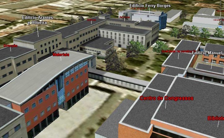
Urbanism and architecture
In real estate, the advantages of using a "Dynamic model" instead of the traditional one where the clients can fly freely, are more than obvious. A dynamic model allows users to consult all the existing information in the neighbourhood. The model can include malls, hospitals, schools, parks, etc., allowing clients to analyze the possibilities of the area, even what they "will see" from their kitchen window.
Turism and culture
Going one step beyond in tourism applications, the projects developed by Terrain Technologies allow the final user, in the planning process, to "forget" about spending hours searching the Internet.
As an added value, any file (video, images, sounds, HTML documents, etc.) can be linked to any object located in the 3D model, allowing the user the possibility to obtain additional information about the surroundings: hotels, restaurants, museums and points of interest.
For rural tourism, Terrain Technologies provides the possibility to add walking trails, cultural routes and simulations of archeological sites.
Engineering
Being the digital terrain model one of the bases of the 3D environment, we can create it using a "future" DTM instead of the "real" one. As a result, it is simple to integrate large infrastructure projects such as highways, bridges, dams, etc. using objects previously defined with AutoCAD o 3DStudio in order to analyze the visual impact of the project. This technology can be used to develop applications based on infrastructure network design (electricity, gas, water) as well as tracking systems. These systems work by inserting dynamic objects in the model (either terrestrial or aerial) that can be tracked in a 3D scene and as a result, location information can be directly accessed from external sources such as a Global Positioning System.
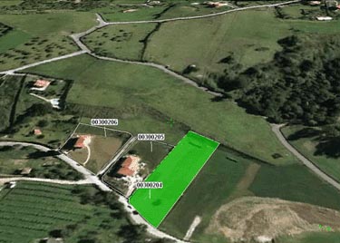
Cadastre
Since GIS data can be imported into the 3D environment and any object included in the model can be linked to any file, it is therefore possible to import and display tabular information for objects loaded from Shape, ArcSDE and Oracle 9i, creating a form of "3D GIS".
We also develops customized applications, adapted to each customer needs.
System requirements